Sunday, August 31, 2008

St George Utah


We left Las Vegas and headed north east along I-15. We crossed into Utah and in response to high winds and, threatening thunder clouds, stopped in St George in the Dixie area of Utah. It is called Dixie because Brigham Young, the second prophet of the Mormon Church of Latter Day Saints and founder of the state of Utah, directed 300 families to settle in the St George area and try to grow cotton. They also planted mulberry trees and tried to grow silk worms, but having to boil every cocoon and then pull out the silk strands was too time consuming for the output. We had never seen a cotton bush, so here is a picture. The settlers next built the Mormon Temple in Utah.
The final picture is a shot of what is commonly referred to as "Nevada Grass".
ASIDE: We didn't travel far between Las Vegas and St. George, because we had discovered that the extreme 117 degrees in Vegas had fried Dave's insulin. We initially assumed that this was not a problem, because in Canada you can buy insulin anywhere and Dave had paperwork (plus his fried stuff) to prove he was a diabetic. Off we went and at the first pharmacy we were turned away. We decided to go to a bigger city and ended up in Mesquite....unfortunately same story at the Walgreens....NO American prescription = NO insulin. Well, we aren't back in Canada until mid-October. Going without breakfast/lunch on one day is fine, but no food for 6 weeks is sketchey. We had to go to the hospital emergency, pay $220 for prescriptions and "related treatment in the emergency" (whaaattt, and they didn't even check his blood sugar levels, but asked lots of typical questions and extra ones about the bikes). Then we had to go back to the pharmacy and pay another $130 for what in Canada would be $40 worth of insulin. Dave is carrying an evaporative gel pack (similar idea as our cooling vests) for the insulin which usually works but that wicked heat killed it.
UPDATE: Upon arriving home we found yet another bill, this one from the doctor (!) as he bills independently for $341. Good grief ! Close to $700 for 6 weeks worth of insulin.

Friday, August 29, 2008

Grand Canyon and Hoover Dam


We took a 16 hour bus tour from Las Vegas to the Hoover Dam and the South Rim of the Grand Canyon. They are building a new bridge over the Hoover due to 9/11, hence this is the last year for actually driving over the Dam itself. The Hoover Dam was constructed during the depths of the Great Depression in only 4 years (1931-35). It is 736 feet tall and holds back 2 years of the Colorado River, at 45,000 pounds/sq.foot....pretty impressive! It got built 2 years ahead of schedule and under budget.....I guess having no computers must have helped.
The Grand Canyon is really spectacular, it is one of the 7 natural wonders of the world and is the most visited one. Interestingly, it has mistletoe trees near by. We saw an IMAX film on the Canyon and stopped at several look out points. Some brave folks rode mules down the narrow trail to the river. The mules are much better at tight switch backs then we are with our bikes, in fact they are referred to as the "long eared taxis" (see picture of them on a path in the distance). Personally I could never ride one down those narrow paths on the side of the canyon, an activity that even Roosevelt took part in. On a more sad note, there are many deaths at the canyon....people of all ages from 4 to 70 taking unplanned dives. There is a lack of perspective looking into the abyss and when people are off the beaten track (so stupid!!), they can get dizzy or loose footing etc. and have no bearings to get reoriented.


Thursday, August 28, 2008

Las Vegas


While in Las Vegas Bev tried unsuccessfully to pay down some of the trip costs, to no avail. There is all sorts of construction of spectacular hotel/casinos along the strip and it won't look the same in 5 years. Many of the hotels feature amusement rides, and you will see a couple that are tacked onto the outside of Stratosphere (the tallest tower structure in Las Vegas). The one Bev is standing near is mini-rollercoaster that shoots its riders out over the edge of the tower....eww, scarey. The other swings its riders over the edge as well. The fountain you see is outside Bellagio (remember the movie "Oceans 11"?) and the fountain's water jets dance beautifully to music. It is almost moving if one could imagine such a thing in Las Vegas.

Tonopah and the road to Las Vegas

While enroute from Yosemite to Las Vegas, we stopped in Tonopah a town about 300 km. north of Las Vegas on route 95. It is a former mining town and Nevada mining towns are even less attractive than BC lumber towns !! While there we met Michael Gabriel who was on an ST 1300 a year newer than Dave's 2006 but equipped with all sorts of fancy and useful after-market travelling items such as: highway pegs that swing out from the crashbars; cruise control; and (remember the former post) a sheepskin seat cover. He was from Edmonton and along the way had stopped off at the Bonneville Slat Flats in Utah and got his machine up to 220 km/hr. Dave was impressed. Bev was more excited because she had left some personal items in a small town that afternoon, Benton, and Michael who was headed that way decided to try and retrieve them, subsequently hoping to mail them to Toronto.
For those of you who might not know, bike riders are amazingly supportive of each other. They are friendly, happy and well-spoken. We hope Michael will visit in Toronto in the future.

Top TEN Clues .......


.....so you know you're in the desert (explanations below).
10. You drink a lot of water, but you never have to visit the washroom.
9. You can never have any exposed skin.
8. Whenever you stop, you pour water all over your clothes.
7. There are more trucks on the road than cars.
6. Whenever you see a sparse tree, you know it is a rest stop but when you get there your cheese has melted.
5. After 10,000 miles in the saddle, Dave has saddle sores and walks like a bow-legged cowboy.
4. People ask "Has your bike overheated yet?"
3. The cactus at the side of the road are taller than you.
2. The road signs now read "Flash flood area"
and finally you find that....
1. The Las Vegas KOA won't let you book a tent site and then suggest an air-conditioned motel because it's 117 in the day and cools only to 96 at night.
Explanations:
10. In a dry heat, you sweat a lot of fluids without realizing it.
9. Bev began to wear a bandana around her face to keep the hot air away, she resembled a bank robber. When the temp. gets over 100 or about 40C, you can't ride a bike with a t-shirt as you loose too much fluid without realizing it.
8. In Edmonton, in anticipation of travelling in the desert, we bought "cooling vests" and these have really been great. They look light regular winter vests, but they are filled with crystals that absorb water. We soke them and they fill with water, creating a gel within the vest. As the air travels through them, it evaporates cooling the wearer. They are great because we can continue to wear our protective leather jacket, yet deal with horrific heat.
7. No one drives unless they have to.
6. At the rest stops there were taps so we could feel our water bottles and trees were set around the picnic tables, like a modern day oasis.
5. The beaded seat doesn't seem to work in this heat. I guess it only helps taxicab drivers with their rear ends. We got some sheepskin in Las Vegas so we'll see how that works in the next couple of days.
4. Ahhh come on....give us a break!!
3. See picture and Dave is 5'11"
2. The highest reason for premature death in the Sahara Desert is drowning....why? because of flash floods. What happens is that when a heavy rainfall occurs, the ground is so hard and dry it can't cope with a lot of water and so it accumulates fast. In the Sahara it can rise to 10 feet in a few minutes, it disappears once it has softened the ground but if you can't swim you're in trouble. The Tuaregs haven't taken swim lessons....We used to see in California "tsumani evacuation" route signs and now this !!!! water rules down here.
1. Well, we had to listen to the KOA.

Tuesday, August 26, 2008

Over Tioga Pass and into the Desert


ASIDE: profuse apologies, we were unable to get a high speed hookup, which is ironic since we were in the Silicon Valley area of California. In any case, tonight we posted five tonight.
Ok, so we left our campsite and headed up hwy 120 across Yosemite. It was an amazing hwy with gentle sweeping curves, no nasty switchbacks, beautiful vistas, and nice cool 75 degree temp as most of the road is between 7,000 and 9,000 feet. In the photos there is a picture of Dave at Olmstead Point with the Half Dome in the background, and one of Bev pointing out the route of the road. If you look at the picture with neither of us, you will see the road we will enter as it crisscrosses the mountain pass. We took this pic from one of the pulloffs.
The last picture is the continuation of 120 to hwy 6 in the Inwo Nat'l Forest in the Nevada high Sierra plains.....it is wide, with mountains on all sides, with sagebrush in bloom and the paved road is straight and you can see where you are headed for miles.....with NO OTHER vehicle to be seen. Bev made a pit stop at the side of the road with no worries!! We felt like we were in a western movie....the scenes were perfect.
We finished the day crossing the Nevada Desert to Tonopah on route 6 and 95. We have treated ourselves to a Best Western with a high speed internet just for you complainers who have wondered why the blog was not in action lately.

Yosemite


We decided to get out of the Bay area on Sunday to avoid traffic. We crossed the Richmond San Rafael bridge - the one that pancaked during the last earthquake and we were on the underside - and drove through Oakland. We continued across the San Joaquin valley and along route 120 to Yosemite. They have (free) shuttle buses that take tourists around to all the sites in the valley (in an effort to minimize the effect of cars on the fragile environment). We saw Half Dome, and El Capitan - a verticle granite rock face several 1000 feet high and with a number of courageous climbers as "dots" on the wall. Unfortunatly all the waterfalls are dry at this time of year so we will have to return in the spring on another trip. We hiked up towards Vernal Falls because the stream below actually had water in it, but only our ankles were strong with the changing of gears and braking on the bikes, so we only made it about 80 % of the way, a feat given the climb.


San Francisco


We stayed at the KOA campground in Petaluma (to be woken up by donkeys in the morning - see the Canadian flag), about 40 miles north of San Francisco. We wimped out and took a bus tour from the KOA. I have to say it was great, we saw Chinatown, the Presidio, Golden Gate Bridge, Fisherman's Warf, Financial District, rode a cable car, Haight/Ashbury district, Victorian homes, and all the usual "stuff" tourists do. NOW, some of you will wonder why the heck did they take a tour? Were they afraid to ride their bikes? YES YES and did we say YES. Do you remember the movie "Bullit" with Steve McQueen? No way we're riding bikes on those roads! One of the pictures shows the roads but the perspective is difficult to capture in a picture. Some of the roads are at 31 degree angles. The cars have to park perpendicular to the direction of the road. I can't imagine opening a door without the weight making it fly into the next vehicle!
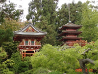
We also visited a Japanese Tea Garden in Golden Gate Park, which had amazingly intricate shrubery and artifacts, buildings and statues. Our oldest son, Brent, spent about 1 1/2 years in Tokyo and so I know he will appreciate this.
We were quite disappointed that we couldn't book a tour of Alcatraz so we just took a picture....we would have had to wait 3 days to get to the Rock.


Highway 1 and The California Coast


We left Highway 101 at Leggett and headed for the coast on Highway 1. The first 8 km was almost straight up with one tight 10 mph switchback after another, no edges to the road and cliffs. At least it wasn't raining!
The Californian coast line is completely different than that of Oregon. It is not a rugged, but rather has never ending beach views. Bev is pointing to the hwy 1 running along above the coastline.
We ended the day camping in a State Park near Mendocino. This is a upscale historic town - think yee olde Unionville by the sea with a touch of California cool.
After Mendocino we continued down hwy 128 through the Anderson Valley, visiting several wineries along the way. NOOO, don't worry, we don't drink while on the bike....you need every oz. of concentration on these roads!

Avenue of the Giants


Sequias and Redwoods are the same, which was news to us (same family, with some taller and skinnier). They stand over 300 ft. and are over 2000 years old. Some were here before the Magna Carta was signed in 1215! (thanks to the efforts of environmentalists) The "Avenue of the Giants" is a road that parallels hwy 101 in California and winds its way through giant Redwood groves. By the way, they are red as they have red tanin in their bark to dissuade insects and disease causing fungus. Jeepers, and we thought tanin was only good for red wine... They have thick bark to protect them from forest fires. In the picture of Dave riding through one, I have to add that it is still alive even though the centre was burned out. The trees redirect their growth after fires, amazing! Their roots are only 6 feet deep, but they intertwine with the others and they balance by growing limbs on the appropriate side of the tree. Now if we could just do that, after having too much red wine tanin we'd be majestic too.

Wednesday, August 20, 2008

Road Signs

OK, in addition to the usual signs you might see on a winding road (e.g., slow down, next turn at 30 mph, etc) we experienced anxious moments with these:
1. motorcycles, use extreme caution, abrupt road edges
2. caution, high wind gusts for next 27 miles (good grief !!)
3. Cape Foulweather
4. Neath the Wind Realty
5. Wild Wind Cafe
and yeah and of course
6 Scenic Pacific ByWay

PS: We are currently about 300 km north of San Francisco in Garberville, a delightful little town with angle parking and amidst the towering Redwoods. There has been no rain here since last winter. Everything is tinder dry, so Bev decided it was time to wash the bike (which was filthy from all the days of rain). Just after she dried it, a light rain started........damn.

Down the Oregon Coast


We have continued down the Oregon Coast through the rain and fog for the last two days. In fact we having been driving in rain for the last four days and we truly understand the meaning of the term rain forest. Highway 101 from Coos Bay to Brookings is is truly spectular with numerous blind curves as it hugs the ragged coastline. As we navigated this challenging road in the heavy rain and high winds we were reminded that this is not just a trip but indeed an adventure. Bev is not overly enamoured with her new 2-piece rain suit.....the seams leak and today her jeans were wet, she had to wring out her gloves, but at least her boots were well made. They managed not to fall apart even though they and her socks were full of water ALL day.

Monday, August 18, 2008

Hitting the Pacific Ocean


After leaving Port Angeles we headed south on infamous route 101 (the Pacific Coast hwy). We stopped for coffee at Forks which was full of motorcycles of all shapes and descriptions (see photo of tryke and scooters) in for a Rain Forest Poker Run Rally.
EWWW, wow to see the Pacific Ocean on a beach near Kalaloch, Washington, the ocean in all its glory, pounding surf, billowing mist and lots of driftwood to sit on for lunch (see photo).

We camped at a KOA at Bay Centre, on Willapa Bay, the Oyster capital of the northwest. There were mountains of oysters shells all over (see photo). We spent a day exploring the Long Beach area which included the Lewis and Clark Interpretive Centre at Cape Disappointment which is just around the corner from Dismal Nitch and a lighthouse marking the entrance to the Columbia river....oh my gawwwd with those names, did these guys not enjoy seeing the ocean...isn't that was President Jefferson wanted Lewis and Clark to do? Actually in the end we agreed with the naming given that it drizzled and fogged most of the day.

We crossed the Columbia River over a loooonggg bridge at Astoria and entered into Oregon.....while the rain, fog and mist continued.
Whenever we left sea level, the rain and mist caused Bev's windshield to become impossible to see through. She had to slow down to try to find her flashers and then to wipe the front of her screen with her hand, which was no mean feat given that she was travelling at 60 km/hr with one hand on the screen, the other on the throttle and 20 cars behind her on wet twisty roads. She was getting frustrated. She could hardly see Dave and the guys backed up behind her must have been swearing. Dave's windshield is adjustable so he had no such problems, I guess Honda got something right! Why don't bikes have windshield wipers....they have everything else such as cruise control, GPS, radios, etc.

In Oregon we noticed that the WasteWater Authority provides excellent service to everyone, notice the public washrooms attached to their office building (see photo of a greatly relieved Bev).

While continuing down route 101 we saw a very large sign on the roof of a building which read "Air Museum" although the building several km. from the road. This building was 200 ft. high and 1000 ft. long and was built during WWII to house 8 blimps that were used as submarine spotters. Each blimp was about 1 1/2 times the size of the Good Year Blimp. The frame of the gigantic hanger was a series wooden arches (see 2 photos one of which includes a plane that survived 29 Gulf War missions and had duct tape over a number of bullet holes).
We are currently staying in Lincoln City, Oregon, treating ourselves to a very nice motel while waiting out a predicted thunder storm.


Friday, August 15, 2008

Victoria


And we thought that rainy day was bad.....oh boy, was today frustrating! Yesterday we has tried to make a reservation for the ferry to Nanaimo, but the website said nothing was available. On spec, we got up at 4:30 am, got packed in the dark and headed out to the ferry dock for 6:30 am departure. Bev had said to Dave "bikers will never be there that early, we're sure to get on!!!" And so we got on. We arrived in Nanaimo and headed down to Victoria. Traffic on the road was heavy and Bev was nervous with all the highway stoplights. Our plan was to stay in a campground just outside the city and then tour the city, but when we arrived at the campground we discovered it was on the side of a very steep hill and the tent sites were perched on the very top. The nice lady at the desk took us up in her golf cart and even that scared Bev. It was 2-way traffic and the downhill cars were cutting the corners....after Bev cried a bit, Dave caved and they moved on. She was determined not to drop that thing again.


Plan B was to see some sites in Victoria, catch the afternoon ferry to Port Angeles in Washington, and find a campsite there. The weather was hot and sunny and the marina area was setting up for weekend dragon boat races so with the grand Empress Hotel, the parliament buildings, etc. there was lots to do and see. Once we got onto the ferry, life turned stressful yet again. There were tie done ropes but nothing to tie them down to. Dave's bike has a tight angle on it's side stand and so we spent the whole trip worrying about it pitching. This worry could not be avoided as one looked rather drunk walking in the ship it was rocking so badly back and forth. That said, the bikes managed to keep upright.


When we arrived in Port Angeles the total town was in a state of traffic gridlock with literally every street with cars and trucks going no where and people swearing....apparently they are replacing two bridges and had closed all the major arterials. On top of that, Bev realized she was really low on gas and the traffic backups were on hilly roads in high heat. After about an hour of stop and go, in desperation we got off the main road, did find gas and finally found a motel (the campground was full). Another scenic route was also be bypassed as Hurricane Ridge road is under heavy construction.


Thank goodness tomorrow is yet another day !!!
BTW, in case you are wondering how many hats Dave is travelling with...only one at a time. You will have seen three in various pictures but when he looses one we just buy another. #1 from Mackinac Island in Michigan, #2 from Cody, Wyoming and the current one #3 from Jasper, Alberta.